Categories
Uncategorized

Landscapes and Local History

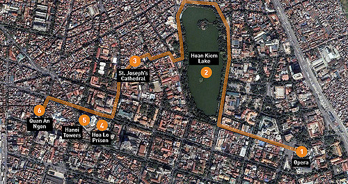
This activity asked for students to experience a mobile public history site or application in the landscape for which it was created. Ironically, this is the gap my project, Nashville Sites, hopes to fill. Nashville currently has no dedicated public history site or application that is non-profit and/or educational. There are  ad-driven/free apps and subscription or purchasable apps such as “City Walks” (a global company that combines corporate sponsors and advertising). Tours and entries are based on a City Walks staff “writing team” but the site also relies on crowdsourced information by users. In Nashville, there are also a few webpages that provide local history based on locations that include Google maps, but they are not particularly mobile friendly nor scholarly.

I decided therefore to use HistoryPin instead and found quite a bit. This was a great experience for me because I have only used HistoryPin once before and it was not in thinking about Digital Humanities (and long before the Nashville Sites project idea was even conceived). Therefore using HistoryPin now, with all of these other things swirling around in my head and online — was extremely helpful as I develop my educational goals and exhibit layers for Nashville Sites. Here is the area that I surveyed both digitally and physically.

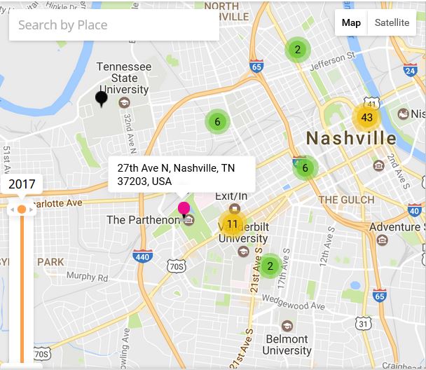
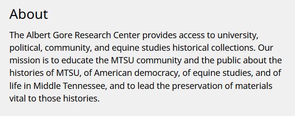
The place-based techniques of HistoryPin for the downtown core and West Nashville have many different collections. Most of the Pins were private citizens and registered HistoryPin users. The majority of the Pins were photographs taken by these users and while the photographs were great there was very little text, narrative, or metadata. Still, most of the major historical sites within the geographic parameters shown on the above map were “Pinned.” The one institutional presence I saw for several instances was the Albert Gore Research Center. Pins placed by the center included not only photographs but also newspaper clippings, political cartoons, and letters.

All in all it was an eye-opening experience and activity that helped me to see what is “already out there” in terms of place-based history in Nashville.  While there are no landscaped-based local public history projects, there is a thriving digital humanities/history program in nearby Murfreesboro at Middle Tennessee State University. For a look at what they are doing see below. They could be a potential partner in the long-run as I (and the MHC) work to develop Nashville Sites.

Digital Humanities at MTSU

Digital Humanities projects at Middle Tennessee State University are created with and for scholars. In addition to images and historical documents, projects include multimedia components, contextual themes, and lesson plans or essays. DH projects are a collaborative effort with content and technology experts who use a variety of digital tools including CONTENTdm, ArcGIS, StoryMaps, Drupal, Omeka and more. Click here for current projects.

I’m also fascinated with Curatescape and hope to use it within my own project. As I seek to develop Nashville Sites, I think about history based on place, I’ve found the Spokane Historical particularly inspiring as a model that is different from mallhistory.org but with many similarities.

Spokane Historical

Spokane Historical is a web and mobile platform for telling stories of Spokane and Eastern Washington. Spokane Historical is a project of the Public History program at Eastern Washington University. Spokane Historical is a free app available on your Android or iPhone smart phone or tablet.


Categories
Uncategorized

“Nashville Sites” Project Proposal

Title:
Nashville Sites: Understanding Nashville’s Narrative using Public Historical Markers
Institution:
Metropolitan Historical Commission of Nashville and Davidson County
Project Director:
Mary Ellen Pethel, Ph.D.
Grant Program:
Digital Projects for the Public: Prototyping Grants

In 1967, the newly-formed Metropolitan Historical Commission of Nashville and Davidson County (MHC) initiated a historical marker program to commemorate significant people, places, and events in the city’s past. With over 150 historical markers now in the county, this program is one of the most successful, and most public projects to date. There is quite an extensive process to erect a marker, but most importantly: “Every statement on a Metropolitan Historical Commission marker must satisfy two conditions: Is it significant? Is it accurate?” (http://bit.ly/2lkfo8Z). For this project, I will begin with these two historical questions and expand to include the following:

  1. How can marker content be complemented with other primary sources to convey a more engaging and important story.
  2. How can this digital history project combine individual entries for markers to create a broader historical narrative for downtown Nashville’s historical site markers.
  3. In what ways can I connect this project to other significant downtown sites  where there are not metro historical markers.
  4. How can I best engage audiences both local and visiting to participate in the walking tour, and how can I best use historical scholarship to support this project.
  5. Are there connections to the broader arts and humanities community that I can easily incorporate?

Omeka will be the primary format for “Nashville Sites” with an interface based on a modified version of “Histories of the National Mall.” This project, sponsored by an NEH grant and developed by George Mason University and the Roy Rosenzweig Center for History and New Media leads the way in digital histories based on public history sites within a particular geographical area. “Nashville Sites” will follow a similar thematic layout based the following categories: maps, explorations, and places. In contrast to mallhistory.org , this project will designate and create a walking tour based on existing, physical historical markers. The site for this project is nashvillesites.org and relevant primary documents will be available for each destination point. These primary sources include images, renderings, and other media files.

In addition to these project resources, digital technologies will enhance metadata available via public records. Curatescape will be used to provide latitude/longitude for geo-spatial mapping, Omeka exhibits will organize marker text and context, and there will also be additional outside links related to selected markers. Points to be included for this project range from the earliest known business to the Ryman Auditorium to historical churches to government buildings.

This format will effectively convey Nashville’s historical narrative based on a humanities-centered approach. Selected markers in the downtown core will be used as the prototype for a larger long-term project will ultimately include all existing markers managed by MHC. The Metropolitan Historical Commission is the steward of two commissions which guide historic preservation projects for metro Nashville. The MHC is funded by the citizens of Davidson County through tax revenues with an annually appropriated budget. In addition, MHC is supported by a separate 501(c)(3)—Metropolitan Historical Commission Foundation (MHCF). The MHCF solicits outside funding and donations for projects that exceed the commission’s budgetary scope. The MHCF has verbally committed to additional funding as this project develops, and the MHC staff is currently collaborating and providing data and sources related to “Nashville Sites.”

The timeline for the project, for this stage, is May 2017. However, it is my hope that funding from MHCF will continue this project until all 150 markers are part of the digital project. There are several targeted audiences: visitors (tourists), local residents, and students. Reaching these audiences will depend on whether or not the project is user-friendly, which is why I am using a web rather than an app-based platform. Evaluation of “Nashville Sites” will be determined, in large part, by the number of hits the site generates from month to month once fully functional.

Distribution and sustainability with specific public user groups will depend on continued support and funding through the MHCF, the development of a social media presence, and the promotion of nashvillesites.org via visible signage on the markers themselves and brochures (and the like) in local businesses and hotels.

Categories
Uncategorized

Connecting the Public to Public History

Nam-ho Park, “A Half-Day Walk through Hanoi,” CC license

There are many implementations and activities that can connect the public to public history using online digital collections. As Sheila A. Brennan and T. Mills Kelly wrote in 2009, the digital humanities are comfortable with the “read-write web.” The Web 2.0 (or 1.5 as they call it) allows public historians to collect and share the stories and narratives of people through their direct participation. Digital history project also benefit from the volunteer efforts of people to identify and enhance their narratives, help to piece together the narratives of others, and provide valuable information and context.

A great example of this can be found in the project “Invisible Australians” that used a facial detection script, tagging, photos, and people to analyze the “White Australia Policy.” Other successful crowdsourcing and public history collaborations include Flickr Commons,  created as a “forum for institutions to share their rich photographic collections. . . and provide insights into how knowledge, skill, and abilities of librarians, archives, and museums can converge in the Web 2.0 environment to provide collection access to new. . . audiences,” (Smithsonian Team Flickr). The Smithsonian Institute’s collaboration is sharing its rich photo archive with Flickr Commons has created an amazing public-private partnership.

In this spirit, the following list includes the kinds of public history implementations and activities that having a basic digital collection enables. 

  1. Tagging, Identification
  2. Transcribing
  3. Exploration
  4. Social Media
  5. Contests
  6. Visual analysis
  7. Direct Collaboration
  8. Geo-spatial mapping (see image at top of post)
  9. Memory-making
  10. Storytelling

Omeka has emerged as the premier platform for open-source digital public history projects.  With a variety of templates, plug-ins, and customization options, most of the items on the above list can be achieved using Omeka’s open source web platform.  For my own project, I will be able to use information from and about historical markers in Nashville’s downtown core. This includes temporal and geographic locations, marker text, and related primary sources. These resources could ultimately be used to create explorations via walking tours, contests for users, storytelling via historical contextualization, direct user collaboration via tagging or identification, and social media. While many of these goals remain quite distant, the fluid nature of DH and the trajectory of rapidly advancing technology make these goals possible.

It remains important to consider several factors that remain critical to the long term usefulness, credibility, and sustainability of digital archives. First archival projects need to be clearly identified. There are many genres and meanings of the word “archive” as noted by Trevor Owen. Ranging from a records or storage management system to what some critics call “artificial collections,” properly defining the mission, scope, and function of an a digital archive is essential (What Do you Mean by Archive?). Likewise the issue of metadata is important. Metadata is not always exciting on its face, but it provides the foundation on which successful digital history projects depend. As the guide for “Describing Metadata” suggests: “Metadata is the glue which links information and data across the world wide web. It is the tool that helps people to discover, manage, describe, preserve and build relationships with and between digital resources” (Describing Metadata).

Coupled with high standards of historical scholarship, digital projects can produce and make available large collections that can be used to disseminate and distribute information to the greater public while also providing countless primary sources to current and future historians. As Dan Cohen and Roy Rosenzweig emphasized in Digital History, “Collecting history through digital archives can be far cheaper, larger, more diverse, and more inclusive than traditional archives. This democratization however, does not mean compromising the quality of the historical work.” (Why Collecting History Online is 1.5).

Works Cited:

Brennan, Sheila A., and T. Mills Kelly. “Why Collecting History Online is Web 1.5” Roy Rosenzweig Center for History and New Media. 2009.

JISC Digital Media. “Metadata: An Introduction.” (first section – “From Metadata: a definition” to “Metadata often reflects the community it has come from.”

Kalfatovic, Martin et al. “Smithsonian Team Flickr: a library, archives, and museums collaboration in web 2.0 space.” Archival Science (October 2009).

Owens, Trevor. “What Do You mean by Archive? Genres of Usage for Digital Preservers.” The Signal: Digital Preservation (blog), February 27, 2014.

Sherratt, Tim. “It’s All About the Stuff: Collections, Interfaces, Power, and People.” Journal of Digital Humanities 1.1 (Winter 2011).

css.php